This time, when we rolled thru ABQ, we were prepared with some trailheads that offered some promising single track. We had taken hwy 14 down from Santa Fe, eliminating the eastward backtrack on I-40. And with the way the Turtle was acting, staying off the interstate was a good idea. Just south of 40, we found a ranger station for the Cibola national forest. Perfect! We could stop in, get a map and some info then be ready to ride! Try again - closed. Why would a ranger station need to be open kn a Saturday when people might actually stop in looking for some help? Oh well.
So we stopped at the first trail head we came to. With no map and really no idea lot where we were going, we opted for a quick out and back ride. Just enough to loosen up the legs before a full day of sitting. The trail we found (coyote canyon - I think) was a multiuse bike/motorbike trail. Not quite double track but not quite single track. It meandered up and across a dry creekbed - mostly smooth but with a few little rock gardens. Tacky and flowing, it was the perfect find for an easy day. There were plenty of other trails peeling off in all different directions, but we stuck with the "main" trail. At least the trail thar had the most tracks in it. It was really easy riding with a gradual uphill. After about 20 minutes of steady pedaling we came to a freshly re-routed section. There was still tape flagging where the trail was going! That section was the most fun - still loose and rocky from the construction, with some fun little tetchy sections. Too bad the rest of the trail hadn't been like that! That would have been really fun! At the top of the climb, we decided to turn around. The wind was picking up and it was starting to get cold, with some ominous clouds moving in. It was a fun but chilly descent back to the camper, with grapple pelting us as we finished.
 |
| The technical section of the trail - having some fun before the long drive |
 |
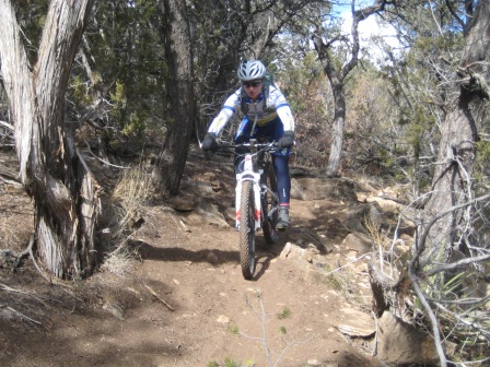
| Nick finishing out the re-routed trail. Don't let the blue skies fool you! |
We will be back. There was a lot of potential there for a few days worth of fun. But we need to get some maps to make the most of it. Not just "here's a trailhead" app on my phone!


Comments
Post a Comment